ABOUT JERICHO - CONSERVATION
Jericho conservation area
Restrictions on permitted development
Posted - January 19, 2013
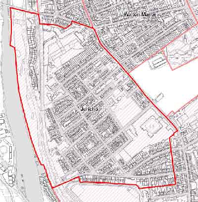
Since February 2011, Jericho has been designated a conservation area. In some respects, this was a rather late designation, since Jericho was surrounded by existing conservation areas in North Oxford, Walton Manor and the Central area. Indeed at its edges some parts of Jericho were already covered by these areas - as indicated in the above map.
A conservation area means that the City Council has additional powers to protect buildings and landscape against alteration, development and demolition. The extent of works you can carry out without the specific permission of the city council is more limited than elsewhere and affects proposals such as extensions, roof dormers, works of demolition, satellite dishes and the application of cladding materials to external elevations.
In addition the Council has further powers of control over permitted development rights through an Article 4 Direction. This applies to a more limited area as indicated in the map below. 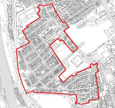 Properties covered by the Article 4 DirectionIn this area planning permission is required for the following changes to the exterior of houses:
Properties covered by the Article 4 DirectionYou can download the City Council study in preparation for the conservation area from the 'Documents' menu to the left. Further information on the conservation area is available on this page of the City Council website.
- The alteration or replacement of windows, cills, arches, surrounds and changes to the dimension of window openings on elevations facing onto a highway or waterway
- The alteration or replacement of doors, door arches, lintels, door surrounds and changes to the dimension of door openings on elevations facing onto a highway or waterway
- The insertion of rooflights facing onto a highway or waterway
- Changes in roofing material
- The erection or construction of a porch outside any external door of a dwellinghouse facing a highway or waterway
- The erection, construction, maintenance, improvement or alteration of a gate, fence, wall or other means of enclosure facing a highway or waterway
- The painting of the exterior of any building or work comprising the painting of unpainted external brick or stone wall, elevation or part of any elevation
- The demolition of the whole or any part or any gate, fence, wall or other means of enclosure facing a highway or waterway
- The installation, alteration or replacement of solar PV or solar thermal equipment on a roof of a dwellinghouse; or a building situated in the curtilage of a dwellinghouse and be visible from a highway or waterway
Other conservation items
Did you know?
Where we work?
According to the 2001 Census, in Jericho 28% of those working were self-employed, while 18% worked part time. Around 20% were in higher professional occupations compared with 14% for Oxford. We also tend to work nearby: 72% of people worked within five kilometres of their home; 18% went to work on foot, 13% by car and 6% by bike
The origins of Nelson Street?
Nelson Street takes its name from a local pub, the Lord Nelson, subsequently renamed Carpenters’ Arms -- which has since been converted to housing.